Author Topic: Accuracy.  (Read 1111 times)

0 Members and 1 Guest are viewing this topic.

Offline tucoblue

  • GBO Supporter
  • Trade Count: (0)
  • Avid Poster
  • *****
  • Posts: 148
Accuracy.
« on: November 28, 2006, 08:36:10 PM »
For three years my ETREX Camo read a certain waypoint to within 2 feet. This year it says I'm 35 ft. from the spot. In other words, I used to stand beside a "Blue Ribbon" tree and the ETREX said I was two feet away from it. This year I can stand beside the same tree and the ETREX says I'm 35 feet away from it. What could have happened to make this difference?

Offline Siskiyou

  • Trade Count: (0)
  • Senior Member
  • *****
  • Posts: 3417
  • Gender: Male
Re: Accuracy.
« Reply #1 on: November 29, 2006, 09:38:15 AM »
The flight pattern of the Satellites change.  Professional surveyors get print outs of Satellite coverage so that they know when they can be most effective.  Levels of accuracy will change during a 24-hour period.  Surveying grade gps units will rent for thousands of dollars. 

Additional satellites have been put into obit this year.  The pay off is the new satellites have stronger signal.  Because of the new launches I have placed my gps units in a good location and let them receive new almanac data from the satellites.

I have found that accuracy varies a great deal.  If I walk up to a location and turn on my gps initial accuracy maybe two hundred feet.  As I settle in the accuracy increases and if I am receiving a three-dimensional signal I may get within the 5-20- foot range.  One of the places I walk is on top of a dam with a lake behind it and open horizon on the spillway side.  In this open location I can see my location decrease to zero because I normally receive ten to twelve satellites on the dam.


A lot of times I will use the Pointer/Compass page as I am closing in on a waypoint.  Note the Dist to Dest box in the upper right corner of the screen.  By following the pointer and watching the numbers decrease in the Dist to Dest box I will close in on a waypoint.   ::)BUT I have seen the Dist to Dest number change when I am stationary. 

Another method is when a user gets up close is to switch to the Map Page.  The Bucks head is the waypoint and the black pointer is the user.  I also have the unit in track mode if I am looking for a small object.  I will walk towards the waypoint until the pointer is on top of it.


As gps signals become stronger and recreational receviers improve users will note that there will be more variances in their data because of the movement of the earth and the satellites.  .  Surveyors use computer programs to correct variances in signals.

When creating a critical waypoint using my 76C or 76Cx I will using the Averaging option to produce a more accurate waypoint location.


There is a learning process to effectively using a gps.  Do not throw your compass and map away!

Boycott: San Francisco, L.A., Oakland, and City of Sacramento, CA.

Offline tucoblue

  • GBO Supporter
  • Trade Count: (0)
  • Avid Poster
  • *****
  • Posts: 148
Re: Accuracy.
« Reply #2 on: November 29, 2006, 12:40:26 PM »
I have noticed I am receiving more satellites this year. Where normally I pick up 4 signals I'm now getting 7 or 8 satellities. I thought that 'ol "Solly" (The ETREX) was just getting better in his old age. Not so I suppose. Thanks for the explanation.

Offline Siskiyou

  • Trade Count: (0)
  • Senior Member
  • *****
  • Posts: 3417
  • Gender: Male
Re: Accuracy.
« Reply #3 on: November 29, 2006, 04:53:28 PM »
tucoblue:  The new satellites have made your older unit better.  You also got me playing around with my gps units.  From my testing today I feel that the signal is strong but I am getting mixed results when it comes to accuracy.  This time I created two waypoints, 115 on one gps unit and 120 on the other unit.  The location(s) are within a foot of each other.
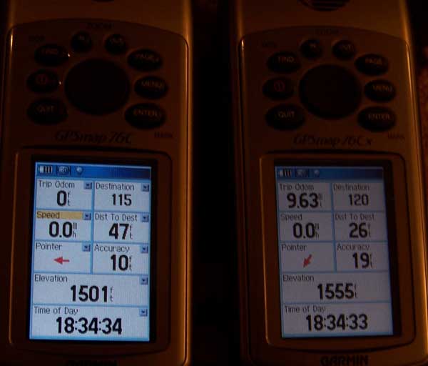


At this point the Pointer can be corrected by walk around in a circle for a minute to get it pointed the correct direction.  The Pointer on the right is correct.  The difference was cause by my movements when setting up the photograph.

The trip Odem on both units is correct.  I had not cleared the one on the right after hiking.

Dist to Dest is incorrect on both units.  This bugs me because normally this is reliable.  Are Air Force guys playing with the satellites today?  They could be, the software in the satellites have been modified.  WAAS is activated on both units.

The Cx unit on the right is receiving more satellites.  The Elevation unit on these units is produced by satellite signals, and not an altimeter. 

As I explain earlier the user needs to follow the black pointer to his location.
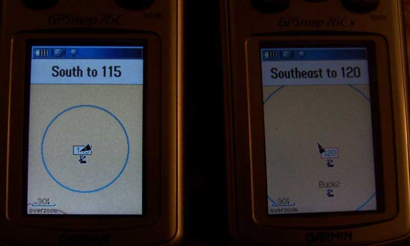


Before jumping to conclusions on this one study the compass rose.  There is only a few degrees difference and this was a result of my moving around and placing the units.  The big difference is the Nine feet difference in Dist to Dest.
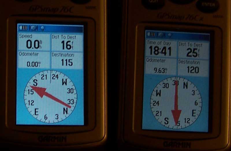


I believe tucoblue has hit upon what is happening with gps satellite signals. 

**Accuracy in these photos was reduced because the gps units were operating under heavy cover.


There is a learning process to effectively using a gps.  Do not throw your compass and map away!

Boycott: San Francisco, L.A., Oakland, and City of Sacramento, CA.

Offline tucoblue

  • GBO Supporter
  • Trade Count: (0)
  • Avid Poster
  • *****
  • Posts: 148
Re: Accuracy.
« Reply #4 on: November 30, 2006, 02:29:50 PM »
While we're here I may as well ask another question (Or two). The elavation value seems to never settle. It's always moving up or down. Is this a normal phenomenon? I've never paid much attention to it but would like know what's going on. I assume the clock is tied to the Fort Collins atomic clock since the unit knows the time in any time zone and adjusts itself for daylight savings time, etc. True?

Many Thanks....

Offline Siskiyou

  • Trade Count: (0)
  • Senior Member
  • *****
  • Posts: 3417
  • Gender: Male
Re: Accuracy.
« Reply #5 on: December 01, 2006, 06:46:19 AM »
Garmin time setting:  I believe that Garmin units follow this format with most of its outdoor gps units.  <Main Menu>Setup>Time>Time Setup>.  At this time the user can chose a number of options.  I always choose 24-hour time, in my case US-Pacific, and set Daylight Savings time on Automatic.

I gave my son the eTrex Legend so I cannot consult it, but I recall changing the factory default from the land of OZ time (Central Time) to Pacific Time.  Garmin’s US headquarters are in Kansas, which is in the Central Time Zone.  Users in other times zones may want to check the setting on their unit.  You need a least 4 satellites to receive accurate time.  It is my assumption that other functions of the gps are affected if it is setup for the wrong time zone.  The satellite clock is far more accurate then the low cost clock in our gps.

I always thought the time was set by the Atomic Clock at the U.S. Navy observatory, but I am not sure.  http://tycho.usno.navy.mil/what.html


Elevation:  Normally to obtain a position with a Garmin gps you need to be receiving three satellites.  Your Satellite Page shows you the strength of reception, your location, and the satellites in relationship to you position.  A couple of items need to occur to get close to your altitude, you need a minimum of five satellites, and the five satellites need to be scattered, not cluster.  Scattered satellites provide better triangulation of your position.  Recreational gps units are not recommended for aircraft navigation.  That + or – 29 feet in elevation may make a big difference between hitting terrain or missing it.  I must say that my father-in-law loves my gps.  He owned a number of small planes for thirty years.  He loved flying down to Mexico. 

The altitude will vary with units that do not have a barometric altimeter.     It is normal to see the altitude change while the unit is setting still.  I have chosen not to buy units with the barometric altimeter as a battery saving measure, cost saving and it is not critical to my outdoor activities.     The user of a barometric altimeter needs to make sure that it is synchronize with an official barometer to get correct readings.                  

There is a learning process to effectively using a gps.  Do not throw your compass and map away!

Boycott: San Francisco, L.A., Oakland, and City of Sacramento, CA.

Offline victorcharlie

  • Trade Count: (0)
  • Senior Member
  • *****
  • Posts: 3574
Re: Accuracy.
« Reply #6 on: December 02, 2006, 03:23:26 AM »
My legend is usually off when compared to the topo map.  Most of the information on several orienteering web sites says not to use GPS elevation as it might be off as much as +/- 400 feet.   On the legend, when I down load the track log and then compare it to the map the elevation "floats".  This is worse in thick woods and on the sides of mountains when the number of sats decreases.

The new Garmin 60CSX advertises a barometric altimeter that's "extremely" accurate and a magnetic compass.

It's priced about $100 more than the CX.........

I'd like to here from some of the CXS user's about the altimeter, power consumption, and receiver sensitivity....

Is it worth the extra $100?
"Extremism in the defense of liberty is no vice. Tolerance in the face of tyranny is no virtue."
Barry Goldwater

Offline Siskiyou

  • Trade Count: (0)
  • Senior Member
  • *****
  • Posts: 3417
  • Gender: Male
Re: Accuracy.
« Reply #7 on: December 02, 2006, 02:24:56 PM »
I need to do a little follow-up with a couple of friends that purchased the 60CSX a few months ago.  I will send them an e-mail and see what they have to say.  Both are in jobs where their gps is a critical item.  Of course they got along with a map and compass in times pass.  Both upgrade from the old gps III+ so they have been gps users for a long time.  They are on duty on weekends so it make be sometime before I get a reply.  Thanks for rattling my cage

I will do some static test and compare the 76C and 76Cx.  As stated earlier the altitude on these models very.  I pulled up the topo for my location and obtained an approximate elevation.  USGS topo maps have an allowable error factor.  I am setting indoors and have my 76Cx turned on.  Currently it is shows a plus or minu accuracy of 20 feet.  When first fired up the unit was off about 100 feet by quickley dropped down to the corrected elevation.  But it has since jumped up and down it elevation plus or minus 20-feet.  Currently it is off approximatly five feet. 

When out in the woods this makes little difference to me.  If I was doing an investigation report I would create a waypoint on a map and state in the legend the gps error factor.  If a few feet were critical to the case I would have a licenses surveyor do a survey of the crime scene. 

Over course the above photo showing the 76C and 76Cx side by side tells a story because the units are indoors.  The 76Cx is very close to being correct.  Within five feet.
There is a learning process to effectively using a gps.  Do not throw your compass and map away!

Boycott: San Francisco, L.A., Oakland, and City of Sacramento, CA.

Offline Golsovia

  • Trade Count: (0)
  • Member
  • *
  • Posts: 90
Re: Accuracy.
« Reply #8 on: December 06, 2006, 04:17:06 AM »
For three years my ETREX Camo read a certain waypoint to within 2 feet. This year it says I'm 35 ft. from the spot. In other words, I used to stand beside a "Blue Ribbon" tree and the ETREX said I was two feet away from it. This year I can stand beside the same tree and the ETREX says I'm 35 feet away from it. What could have happened to make this difference?

Have you ever noted which satellites you're receiving when you're in that location? Varying satellites could have an effect on this. So, too, the amount of error one gets as they move around. Generally the more satellite signals you're using, the better the accuracy, but they also need to be spread out across the sky to get diverse "triangulations."

Variations while standing still are also to be expected since accuracy is never withing zero feet and the signals are not a continuous "wave" (I don't believe anyway.) It's also possible to get a signal that isn't real strong so there may be a bit of "static" with the signal cutting in and out.