Author Topic: Garmin GPS issues  (Read 2534 times)

0 Members and 1 Guest are viewing this topic.

Offline irocbarry

  • Trade Count: (0)
  • Member
  • *
  • Posts: 9
Garmin GPS issues
« on: August 05, 2008, 06:45:22 PM »
Last fall I bought a Garmin map60 gps unit.  While hiking it would have the path that I supposedly took make straight line paths thta were anywhere from 1 to 4 miles long, at speeds of 400mph at times.  Which makes the gps pointless to me who bought it mainly for distance tracking, and trail marking.  I took it back to the store and they sent it to Garmin, who refunded the money for it.  I recently replaced it with a Rino120 and took it to Glacier National Park last weekend.  The unit looked like it was working great until I was stopped at the top of the Hidden lake lookout, then proceeded to make the same type of straight line errors as the previous unit.  Am I having a streak of bad luck or is this a common issue? I'm about to give up on the gps and go back to guessing how far and where I was.

Offline Siskiyou

  • Trade Count: (0)
  • Senior Member
  • *****
  • Posts: 3417
  • Gender: Male
Re: Garmin GPS issues
« Reply #1 on: August 06, 2008, 04:57:33 PM »


I am burned-out right now but I may have an answer the line error, but none for the 400 MPH error.  I need to articulate an answer for you, and will come back to the subject. 
There is a learning process to effectively using a gps.  Do not throw your compass and map away!

Boycott: San Francisco, L.A., Oakland, and City of Sacramento, CA.

Offline Siskiyou

  • Trade Count: (0)
  • Senior Member
  • *****
  • Posts: 3417
  • Gender: Male
Re: Garmin GPS issues
« Reply #2 on: August 07, 2008, 04:19:49 PM »


Both the GPSMap 60 and Rino 120 come with a basemap and the ability to store other Map Source products such U.S. Topo or Topo US 2008. 

I am making a few assumptions based on the information you provide. 


Assumption:  You have created a waypoint and you selected it to Navigate to.

As an example you created a waypoint where you parked your vehicle (P1) and you have hiked to Hidden Lake Lookout.  Now you want to hike back to your vehicle.  You select Find P1 in your Waypoints, and you select GoTo. 

I just did the task while setting here.  I selected Buck Mountain, the Buck Mountain Page comes up and it shows the Latitude, and Longitude that Buck Mountain is located at.  It also shows that it is located 4.47 miles North of my location.  This page has no speed option.

I am given three options at the bottom of the page, Delete, Map (view), and Go To.

I select Go To.  The Map Page pops up and it says to Buck Mountain across the top.

Another option has popped-up saying Follow Road, or Off Road.

I select Off Road, and the Map Page has a “Straight Line” to Buck Mountain.  Across the top is a Message saying NE to Buck Mountain.  Down in the lower left corner is the number 12, which is the scale of the map page I am viewing.  The number in the lower left corner changes as I run the map scale up close or covering the State.

Realistically the hiker cannot hike the straight line, because the topography dictates the route you take.   
http://www.glacieradventure.com/play/Recreation/Hiking/HiddenLakeLookout/index.htm

I use the Track mode a lot in my current and past Garmin gps units.  While they may have different buttons the Garmin Legend, 76C, 76Cx, and the Rino HCx operating language is similar.  My tracks are never in a Straight Line.  I have transferred them from my gps units and displayed them on Garmin Map Source U.S. Topo maps, and USGS Topo Maps.  There are a few times I would have drown in a lake or fallen off a cliff if I had not circled around them.

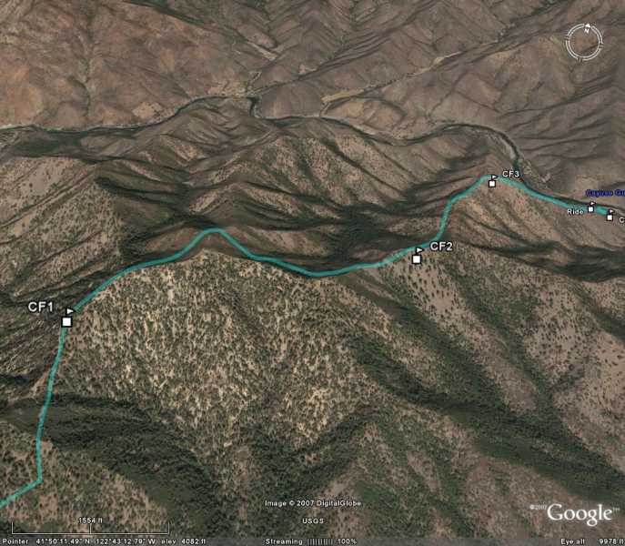
Sometimes I create a route, especially if somebody is going to pick me up at the bottom.  Again I follow the country and not a straight line.  I downloaded this route to Google Earth.


In this case I have my Gps Compass set up as a pointer and I am using it to navigate me to a successful stand.
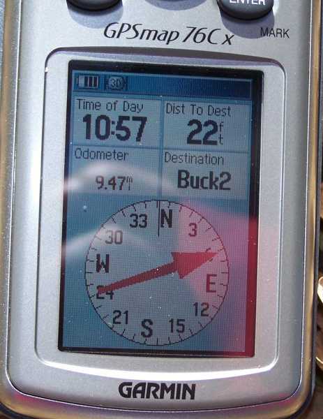


Electronics will interfere with a gps at times, and I always have a compass and map in the woods.

I use my gps a lot and I set up navigation problems in the woods and on the street for self training.  I have left my pickup in the woods and found it hours later taking a different route back to it.  I have used it a lot on the water to return to fishing hot spots, without a problem.  The Garmin Legend worked so good on my boat that I bought a fishfinder/Gps package for the boat. 

A couple of months ago I purchased a Garmin automotive gps.  It seems to operate in a different mode then the handhelds, but has excellent repeatability, and the software is great for finding address, hospitals, restaurants, and other sites.  The displayed speed of the automotive gps and the handheld gps units when used in my pickup display a similar speed as the speedometer.   
 
I failed to mention the RECALCULATE option.  I will create another post.


There is a learning process to effectively using a gps.  Do not throw your compass and map away!

Boycott: San Francisco, L.A., Oakland, and City of Sacramento, CA.

Offline Siskiyou

  • Trade Count: (0)
  • Senior Member
  • *****
  • Posts: 3417
  • Gender: Male
Re: Garmin GPS issues
« Reply #3 on: August 07, 2008, 08:12:51 PM »


As I mention yesterday I running on tired and slightly burned out.  I have felt that way when hunting for two or three days.  I have put on a lot of miles, and made a quick meal, hit the sack to wake-up early the next morning.  It is late and I have been on a track for hours.

It is time to return to camp from the North side of Buck Mountain.  I had created a Waypoint at camp, identified it with the tent icon, and name it Camp. 

I select the Find button, and then the Waypoint Icon.  I hit the Enter button and I get a page with the heading “All Symbols Near Current Location.”  I scroll down to the Tent labeled Camp.  I select it and use the GO TO I described in the earlier post.  The “STRIAGHT LINE” appears on the map page going directly to my camp.  I use the “STRIAGHT LINE” as a general guide knowing I will have to modify the route at times.  When I detour around some rock bluffs, I select Menu and get a drop down.  From the drop down I select “RECALCULATE.”  This effectively moves the “STRIAGHT LINE” between my new position and the Camp Waypoint.

Last summer I believe I posted a pre-planned return to my pickup after scouting an area.  The return was in the dark, before moonrise.  The area was covered with head high snowbrush, thickets of timber regeneration, and old logging slash on the ground.  It was like being in an inkbottle and I had to check the gps about every hundred feet to stay on course.  I switch back and forth between the map page and the compass page checking the pointer.  I had extra batteries with me and I kept the screen backlight.  A straight line was impossible between the vegetation and the down slash, but quick glances at the screen kept me on course to my pickup.

You can recalculate your route as often as needed.  One of my favorite walks is along and a lakeshore, and I have a waypoint at a location.  The lake has a number of small arms that I must go around, and not the most direct route to the waypoint.  During my walk I will take advantage of the Recalculate option.  I try and practice the options I use on the gps so that when I am tired and burned out they become automatically. 
There is a learning process to effectively using a gps.  Do not throw your compass and map away!

Boycott: San Francisco, L.A., Oakland, and City of Sacramento, CA.

Offline Sweetwater

  • GBO Supporter
  • Trade Count: (17)
  • Senior Member
  • *****
  • Posts: 1286
  • Gender: Male
  • When it ceases to be fun, I shall cease to do it.
Re: Garmin GPS issues
« Reply #4 on: August 09, 2008, 01:37:44 PM »
As a Sportsman and a Surveyor, I get to use handheld gps units quite often, though I have rarely taken the time to dig very deep into their capabilities. My main unit is a Magellan Meridian Gold, very much used and probably completly outdated. My boss just went through a couple Magellan XL2000, I think is what they were, then switched to a Garmin in the Map series, but I do not know which one. He is so far very impressed with the Garmin. Your point about recalculation is interesting. My Magellan displays a line from point of origin to selected waypoint. As I 'wander', it displays a lighter line from present position to selected waypoint, as well as bearing and distance. I assume your recalcs are from succeding present positions to selected waypoint and my queston is 'why?' Does not your Garmin display bearing and distance from present position to selected waypoint? Mine Magellan shows it in a box at the lower end of the map screen.

The question is prompted by the need to upgrade my Magellan in the near future and sorting out some of the features available on the newer models. One of my partners has a Garmin Rhino 530. Another partner a few years ago had a Garmin Rhino 120. He said the radio was short-ranged compared to other fmrs/gmrs radios he had used in the same terrain. Radios have become an issue with me and I am presently experimenting with various Cobra models on simplicity, range and features. Some have a very annoying delay from time mic is pushed to when you can start transmitting. Otherwise the receiving party misses the first have dozen words spoken. I have a pair now that do not do that and it is very much appreciated.
Does your Rhino have this delay in the transmitter?

I have been monitoring your posts for several months and have found your stuff very informative and interesting.

Thank you and feel free to respond at some future time - not necessarily right now as there is no sense of urgency here.

Regards,
Sweetwater
Regards,
Sweetwater

Courage is being scared to death but saddling up anyway - John Wayne

The proof is in the freezer - Sweetwater

Offline Siskiyou

  • Trade Count: (0)
  • Senior Member
  • *****
  • Posts: 3417
  • Gender: Male
Re: Garmin GPS issues
« Reply #5 on: August 09, 2008, 05:44:10 PM »

When I have my Garmin navigating to a Waypoint, I normally have the Compass Page setup as a Bearing Pointer.  The Pointer points at the Waypoint and the Compass Ring in background shows.  A second option is to have the needle setup as a Course Pointer, you get the same Compass Ring in the background, and in addition you get a broken line displaying your relationship to a route leading to the destination.

The user can set the Compass Page up to have Three or Four data fields on the Compass Page.  The user can choose from the following option to be displayed:

Trip Odometer
Trip Time – Moving
Trip Time – Stopped
Trip Time – Total
Turn
Velocity Made Good  (Must be for when fall cliff)
Vertical Speed
Vertical Speed to Dest.
Water Speed
Water Temperature
Waypoint At Dest
Waypoint At Next
Accuracy of GPS
Bearing
Course
Depth
Distance to Destination
Distance to Next
ETA At Destination
ETA At Next
Elevation
Glide Ratio
Glide Ration to Dest
Heading
Odometer
Off Course Pointer
Speed
Speed – Maximum
Speed – Moving Avg.
Speed – Overall Avg.
Sunrise
Sunset
Time To Destination
Time To Next
Time of Day
To Course

I normally have my units setup with four data fields.  Every once and while I change the data fields around on the unit I am using to fit the current need.  During hunting season I want to keep track of Sunset, I wish to avoid conflicts with the Game Warden, and prefer to be walking the nearest road rather then busting my can in the timber when it gets dark.


The Computer page is my favorite page because it gives me more Data Fields to work with.  One of the Data Fields is normally setup as a Pointer.


The Straight Line discussed earlier appears on the Map Page when Navigating to a Waypoint, City, or Point of Interest.  My priority pages are the Computer Page, Compass Page, and Map Page.

While I refer to the Map Page to get a visual reference to my destination for comfort, the best information is being generated off the Computer Page.  On a typical fishing day I will be out trolling and I pickup a school of fish on my fishfinder.  A rod tip starts balancing and I hit the Enter button and generation a waypoint.  On windy days my boat has been blown five or six hundred feet from the strike location.  I re-rig my pole and using the Compass Pointer I navigate back to the school of fish. 

Times have changed, years ago in the Sea of Cortez I used my compass to shoot a bearing off a couple mountain tops, and record the results in a pocket notebook.  The trick was when my father-in-law returned on another day.  The old compass did a good job, but the gps is far better and simpler. 

For years I have received good service from a couple of Midland FRS/GMRS units.  A hunting partner already had a Garmin Rino 530 and found a good sale price on the 530HCX.  I went along and purchased one.  At this point I am not a totally satisfied customer.

My hunting partner lives 250 miles from me so we have not had an opportunity to get together and test them side by side.  I must say that he and his son are happy with the two units they have.

From accuracy stand point I like the unit.  I am having mapping issue and when time allows I need to contact Garmin regarding those.

I have had a very busy summer and have not had time to give the unit a fair test.  I would like to test the Polling feature.  An acquaintance is part of a group that runs around out in the Nevada Sagebrush on ATV’s.  He has Rino 120 units and is very happy with them.  I am currently withholding a recommendation of the Rino 530HCx until I get more time with it.

A feature I like is the ability to create Proximity Waypoints.  I have used them to sound an alarm at a waypoint I created at a nondescript jump-off point, and a dangerous mineshaft.  The user determines the distance from the point the alarm goes of.  All the Mapping Garmin Units that I have used have this feature.  This would have been nice to have back in the days when I would cache rations and water in the back country.

These gps units are little computers chuck full of options, but the basic defaults well get the average user by. 


There is a learning process to effectively using a gps.  Do not throw your compass and map away!

Boycott: San Francisco, L.A., Oakland, and City of Sacramento, CA.

Offline Siskiyou

  • Trade Count: (0)
  • Senior Member
  • *****
  • Posts: 3417
  • Gender: Male
Re: Garmin GPS issues
« Reply #6 on: August 11, 2008, 12:10:25 PM »
(August 11, 2008)

The Moving line, (Projected line), on my Garmin Rino 530CHX now moves as I move.  This is the line that is projected on the Map page, from my location to the selected Waypoint.  When I started years back with the Garmin Legend the projected line moved as I moved.  The post by irocbarry, and Sweetwater have me playing around a little more with my gps units. 

Recently I found a software update for my 530CHX.  This was a new out of the box unit a few months back, but there is already an update. 

Irocbarry does your Rino 120 have the latest software update?  http://www8.garmin.com/support/collection.jsp?product=010-00270-02

This morning I took a walk and select the Dam1 waypoint in my unit.  Immediately a line projected across the map page with one end at my location and the other end at the location on the Dam I had created the waypoint.  The position marker (an arrowhead shaped object) shows my position, it moves as I move or stays static if I am not moving.

There are a couple of ways of getting Garmin Gps unit updates, one is to go to the support page and then find the Model as I did for the Rino 120.  Another way is to use Garmin’s Web Updater.  Every once and while I will get an update on the Web Updater that is not found with the Unit updates.  It appears the Web Updater is a more complete source.  http://www8.garmin.com/products/webupdater/howtoinstall.jsp


On occasion I load the update to my Garmin file, located in my documents.  One of the reasons is every once and while there has been an issue with the Garmin updates.  One of those issues was the loss the loss of the Moving Projected line across the Map.

This mornings walk was with the Rino 530CHX, tonight's or tomorrows will be with a different unit.  I need to test those new updates I download in the last couple months.  Work has been very time-consuming the last two months and I miss my walks.  I need to get another walk in before I get back to work later this week.

P.S.  I tried taking a few screen shots this morning with my camera phone, if they come out I will post a couple to illustrate the Projected Line.


There is a learning process to effectively using a gps.  Do not throw your compass and map away!

Boycott: San Francisco, L.A., Oakland, and City of Sacramento, CA.

Offline Siskiyou

  • Trade Count: (0)
  • Senior Member
  • *****
  • Posts: 3417
  • Gender: Male
Re: Garmin GPS issues
« Reply #7 on: August 11, 2008, 06:11:17 PM »
(August 11, 2008, Days End)

I will need to take some screen shots on another day; I was getting to much glare out in the field today off the gps screen for good pictures.  I need to try with real camera.

Sweetwater:  I conducted a number of tests with the Radio side of the Garmin 530HCx today.  I experienced no delay in transmission.  I did the standard 0,1,2,3,4,5,5,4,3, 2,1 count transmitting with the 530HCx and receiving on a Midland radio.  I then repeated the test, transmitting on the Midland and receiving on the 530HCx.  I experience no delay on either side.  I must note the quality of the 530HCx speaker appears to be superior. I repeated the test often enough that my wife was giving me the look.

You mention earlier that your Magellan has one or more Data boxes on the Map Screen.  My Garmin units offer the following options on the Map Screen:
Map Only
2 Data Fields
3 Data Fields
4 Data Fields.

I prefer not to clutter the Map Page, and have selected Map Only.  On a random hunt I get an uncluttered map, if I need additional information I can rock back and forth to the Compass Page or the Computer Page.  When Navigating to a Waypoint, or other location a box appears at the top of the map with the Waypoint identifier in it.  But the options allow the user to setup the unit to fit his needs.

Irocbarry the manual for the Rino clearly lacks detail.

Go to page 29 in your Rino 120 Manual.  It is titled Setting up the Map.  Select the Sub-Page Button.


1.   Select the Setup Map from the option Menu and then press the Thumb Stick in to display the Map Setup Page.
2.   Press the Thumb Stick to highlight the little icon that looks like a snake.  This is the lines setup icon.  You will get an option at the bottom of the drop down called, “Go To Line.”  Select Bearing, which will allow your Map Page to display the “Projected Line” i.e. the Moving Line to move with you.  If the Course Option is selected, and you walk in any direction except directly on the Projected Line you will leave it. 

This issue has bugged me with my now discontinued 76C.  Today I worked with the 76C, 76Cx, and the 530HCx.  Of the three units the 76C was not tracking with me.  I went to the Map page and started checking the Line options.  When I looked at the Options, Bearing and Course I thought I had found the problem.  I then went to the properly operating 76Cx and checked the Line options and found that Bearing had been selected.  I selected Bearing on the 76C and the Projected Line is now a Moving Line.

The other thing I did today was to plug my gps units into the computer.  I went to Start>Programs, Garmin, and Web Updater.  There was a Chipset Update for the 530HCx.


There is a learning process to effectively using a gps.  Do not throw your compass and map away!

Boycott: San Francisco, L.A., Oakland, and City of Sacramento, CA.

Offline Sweetwater

  • GBO Supporter
  • Trade Count: (17)
  • Senior Member
  • *****
  • Posts: 1286
  • Gender: Male
  • When it ceases to be fun, I shall cease to do it.
Re: Garmin GPS issues
« Reply #8 on: August 12, 2008, 06:32:27 PM »
On the Magellan map screen, there is an option to show data or hide data. If show data is selected, two boxes appear at the bottom of the screen, displaying bearing and distance to waypoint from present position.

Checked with the boss today, his new Garmin is in the Map 60 series. So far, he is still quite impressed with the unit.

I, too, noticed the clarity in the 530's speaker. I am hard of hearing and do not wear my hearing aids at work as I sweat too much and they start to crackle from the moisture. It seemed the 530's speaker was basically free of static/noise and was easier to understand the transmissions. Of my new Cobras; the 170's are lower powered than the 190's, therefore should have less range. However, using them around the yard, my wife and I have found the 170's to be easier to understand. The 190's seem to have more noise; i.e.less squelch? They are the same size and on the same platform. Neither of them experience the transmission delay that I get with the 5000, 4700 and 3800 models. Am wondering if this delay is being caused by the VOX capability of these radios, even though the function is switched off. Just a bit of thoughtful wondering.

Regards,
Sweetwater
Regards,
Sweetwater

Courage is being scared to death but saddling up anyway - John Wayne

The proof is in the freezer - Sweetwater

Offline Siskiyou

  • Trade Count: (0)
  • Senior Member
  • *****
  • Posts: 3417
  • Gender: Male
Re: Garmin GPS issues
« Reply #9 on: August 13, 2008, 12:29:50 PM »


I do not have any (VOX )Voice Operated Transmission and accessories for the 530HCx or for my Midland FRS/GMRS radios.  It would be good to have a Garmin Ear Bud speaker/mike in my accessory kit.  My style of hunting and radio use calls for setting up three check-in times with my hunting partners, 1000, 1200, and 1500.  At sundown the radio goes on until everybody is together.  I feel the radios become a distraction to the hunt and a give away to game.  Check in times get missed, and hopefully we make contact at the next check-in.  A couple of years ago I was setting in my ground blind and about a dozen deer moved in.  There was no way I was going to turn a radio; it spends most the day turn off and tucked away.

The Ear Bud could go in place of my hearing aid, leaving the other one to listen for deer and rattlesnakes.

A young, rookie has married into the family and I might change my way of doing things.  I am considering buying a couple of over ear headsets for the Midland radios.  I do not consider them a hunting tool, but a safety tool.  Back in my youth a friend's father broke an ankle out climbing around the lava rocks in the NE California.  If they had radios his hunting partner could have helped him much sooner 

As an oldest child by nature I am a worrier and a sense of responsibility that younger sibling did not have in their youth.  I wonder if I outfitted in-law with one of those Astro Dog tracking systems if I would be in violation of the Fish & Game code?  I think the probation is using it on dogs while hunting, not in-laws.


https://buy.garmin.com/shop/compare.do?cID=209&compare=compare&compareProduct=8576

P.S.  Garmin is currently offering a $50 Rebate on Rino 520HCx and the 530HCx

http://www8.garmin.com/whatsNew/currentpromotions/


There is a learning process to effectively using a gps.  Do not throw your compass and map away!

Boycott: San Francisco, L.A., Oakland, and City of Sacramento, CA.

Offline Sweetwater

  • GBO Supporter
  • Trade Count: (17)
  • Senior Member
  • *****
  • Posts: 1286
  • Gender: Male
  • When it ceases to be fun, I shall cease to do it.
Re: Garmin GPS issues
« Reply #10 on: August 15, 2008, 06:56:25 PM »
I use an over the head mic set with my Cobras after the ear bud died (very light wiring and we use them under fairly severe conditions on construction sites). My hearing aids are the 'behind the ear' style and the headphone works very nicely with them. I do not get feedback while wearing them.

I just visited the Garmin site, primarily to view their rebate programs. Looked up the Rhino series and did the comparison checks and found the 530 does have VOX capability, so it must simply be a product of Cobra electroncs that causes the transmission delay. I have a buddy that takes road trips with his wife on a big Honda Goldwing. He says his helmet radios have a delay and he believes it to be caused by the VOX system. Interestingly, they are Cobra radios.

Are the FRS channels like 1-7 and GMRS 8-22? I've lost the paper with that info on it.

Your opinion solicitated:
                               1/  replacement model for my Magellan Meridian Gold? One of the 60 series? Or which one?
                               2/ Onboard GPS (a) stationary or movable between vehicles? (b) Which one?

Regards,
Sweetwater
Regards,
Sweetwater

Courage is being scared to death but saddling up anyway - John Wayne

The proof is in the freezer - Sweetwater

Offline Siskiyou

  • Trade Count: (0)
  • Senior Member
  • *****
  • Posts: 3417
  • Gender: Male
Re: Garmin GPS issues
« Reply #11 on: August 17, 2008, 08:48:09 AM »


Ch 1-7  GMRS
Ch 8-14 FRS
Ch 15-22 GMRS
Ch 15R-22R GMRS Repeater with units that have repeater ability.

I like the 60Cx, 60CSx, and prefer the 76Cx, and the 76CSx.  I prefer the 76 series to the 60 series because I spend some time out on the water and the 76 series floats, and the 60 series sink

http://www.gpsnow.com/gmmap60csx.htm#info
http://www.gpsnow.com/gmmap76cx.htm

I have a couple of friends that have used them on the job and they love the 60CSx.  One is a snow ranger who is out under the toughest conditions, and purchased a personnel 60CSx when he turned his in on retirement.  The last time I talked to him about the altimeter feature he was not completely happy.  But it might be a matter of not having time to practice with it.  Hopefully the time will come with retirement. 

I did some testing with my altimeter in the 530HCx.  The only stations that provide pressure are at 2000 feet higher then me or 1000 feet lower.  This can be an issue in calibrating it.  Again I repeat I am in the learning process.  On this mornings walk of a little over three miles I stopped at the nearest contour line on my US Topo map and used the elevation from it to calibrate the unit.  I then checked the elevation at five different locations as I crossed contour lines on the map.  The greatest difference was 30-feet.  The least difference was 2-feet, the average difference was 10-feet +or -.  I checked the pressure at the two closes stations showing pressure there was a 00.02 raise in pressure during my walk.

I have looked at the Magellan Triton Series and the Triton 500 happens to have high sensitivity receiver.  I was in a Costco recently and they had a bunch on sale with software.
http://www.magellangps.com/products/product.asp?segID=425&prodID=1910
http://www.costco.com/Browse/Product.aspx?Prodid=11287020&whse=BC&Ne=5000001+4000000&eCat=BC|79|4842&N=4001412%204294966517&Mo=2&No=1&Nr=P_CatalogName:BC&Ns=P_Price|1||P_SignDesc1&lang=en-US&Sp=C&topnav=


Having had my hands on a Garmin 60CSx, a 76C, 76Cx, and the 76CSx, along with the Triton 500 I prefer the 76 series because of how the buttons and screen are set up.  With a 76 cupped in my right or left hand I can easily operate the buttons with my thumb.  It is more difficult to do with models with the buttons on the bottom.

It has been my opinion for a long time that the electronic compass and altimeter are not critical features for my applications.  Having played with the electronic compass I like it, but user needs to remember to recalibrate it if he changes locations, changes batteries, or if there is a change in the weather.  If the user does not pay attention to those things, I would recommend turning off the electronic compass feature, and using the gps (satellite compass).  Before hunting season I will switch my over to the gps compass feature.


There is a learning process to effectively using a gps.  Do not throw your compass and map away!

Boycott: San Francisco, L.A., Oakland, and City of Sacramento, CA.

Offline Siskiyou

  • Trade Count: (0)
  • Senior Member
  • *****
  • Posts: 3417
  • Gender: Male
Re: Garmin GPS issues
« Reply #12 on: August 18, 2008, 11:52:13 AM »
Sweetwater:  I answer the automotive part of the question at c550 topic.

There is a learning process to effectively using a gps.  Do not throw your compass and map away!

Boycott: San Francisco, L.A., Oakland, and City of Sacramento, CA.