https://www.livescience.com/57927-new-zealand-part-of-eighth-continent.htmlBy Tia Ghose February 17, 2017 Planet Earth
Based on geological definitions of a continent, the Earth actually has a lost eighth continent, known as Zealandia. Most of this continent is submerged beneath the sea, while a tiny sliver, including New Zealand, is above the water.
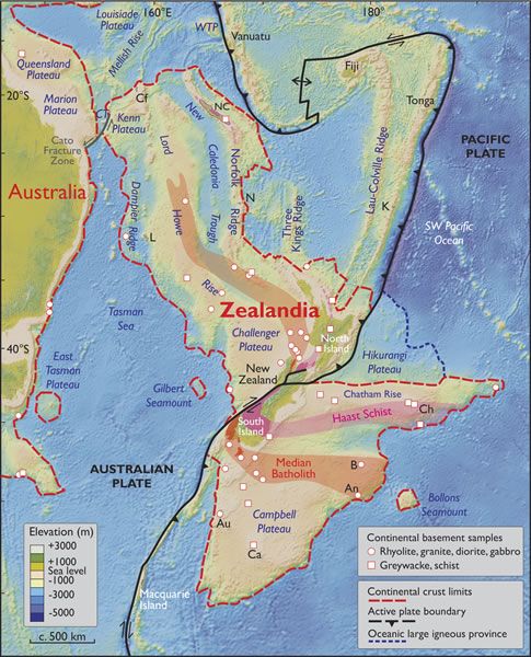
(Image: © GSA Today 2017)
Earth has eight continents, and world maps should reflect this, geologists say.
The eighth, a lost continent called Zealandia, isn't a huge landmass that geographers have somehow missed. Rather, only small bits including New Zealand, New Caledonia and a few other specks of land in the vast Pacific Ocean are above sea level. The rest of this continent lies beneath the waves, a new study suggests
"I hope Zealandia will now start to appear on world maps which show the other continents," said Nick Mortimer, a geologist with GNS Science in Dunedin, New Zealand. "There is an extra one, and it is as real as all the others." [Photos: The World's Weirdest Geological Formations]
Decades of evidence
The new study synthesizes decades of evidence for a hidden continent lying beneath the ocean surrounding New Zealand. The first line of evidence comes simply from looking at the ocean floor around New Zealand: The continental shelves of Zealandia lie at a depth of about 3,280 feet (1,000 meters) below sea level, while the nearby oceanic crust is about 9,800 feet (3,000 m) below that, Mortimer said. Just like other continents, Zealandia has a huge range in altitude, from the sub-ocean depths to Aoraki/Mount Cook at 12,217 feet (3,724 m) above sea level.
The second line of evidence supporting Zealandia's designation as a separate continent comes from extensive study of the rocks beneath the ocean. Over the past 20 years, geologists have set sail on ships to dredge rocks from the seafloor. Unlike the nearby oceanic crust, which is made up of basaltic rocks from the fairly recent geologic past, the crust surrounding New Zealand is composed of a variety of different rock types, including granite, limestone and sandstone, some of which are incredibly ancient. That is typical of continental crust, the researchers reported in the March/April issue of the journal GSA Today.
Finally, scientists have shown that there's a narrow strip of oceanic crust separating the continent of Australia from the subterranean reaches of Zealandia, meaning the two are separate continents, Mortimer said.
Ancient formation, distant future
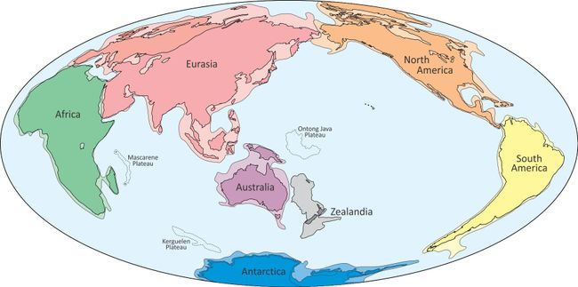 A proposed world map showing the eighth continent Zealandia. Though most of this continent is submerged beneath the ocean, scientists say it has all the geologic hallmarks of a separate continent.
(Image credit: Nick Mortimer/GNS Science)
Zealandia was born from the breakup of the supercontinent of Gondwana, about 85 million years ago, Mortimer said. At that time, an ocean began to emerge between Australia and New Zealand.
"Zealandia is somewhat unusual, in that just before it separated from the supercontinent of Gondwana, it got stretched," Mortimer told Live Science.
That stretching essentially thinned out the continental crust, making it sink more than thicker continental crust, which tends to float, he said.
Compared with other continents, Zealandia is pint-size; at 1.8 million square miles (4.9 million square kilometers), it's a little bigger than India and half the size of Europe.
And although only a tiny amount of the continent is lying above the water currently, at one time, its above-water footprint was even smaller. Based on geologic layers unearthed on New Zealand, the continent reached its maximum level of submergence about 30 million years ago, Mortimer said.
Now, the movement of the Australian plate is cutting Zealandia in two, which should break the continent in half in tens of millions of years, Mortimer said.
While the new findings are unlikely to change seismological maps or hazard assessments around New Zealand, "I think it will focus minds; it's just a more correct depiction of the geology and tectonics of this corner of the planet," Mortimer said.
From a geological perspective, defining Zealandia as a continent makes sense, said Bruce Luyendyk, a professor emeritus in geology at the Univeristy of California at Santa Barbara, who first coined the term "Zealandia."
As to whether maps should reflect this geologic reality, "That's a question answered by geographers and politicians, not geologists," Luyendyk told Live Science.
But there's some precedent for recognizing the continental boundaries that lie beneath the water, Luyendyk said. Other continents have continental shelves that project deeper out into the ocean, and the United Nations Convention on the Law of the Sea, which sets the economic limits of a nation along its coastline, already recognizes these geologic boundaries, Luyendyk said.
Originally published on Live Science.

